Sponsor:
Advanced Scientific Computing Research (ASCR) under the U.S. Department of Energy Office of Science (Office of Science)
Project Team Members:
Northwestern University
The HDF Group
- Quincey Koziol
- Gerd Herber
Argonne National Laboratory
North Carolina State University
- Nagiza Samatova
- Sriram Lakshminarasimhan
Damsel Usecase - NASA Grid
HDF-EOS grids and swaths are the most common structures.
HDF-EOS Grids
For an introduction see section 6 of [HDF-EOS1].
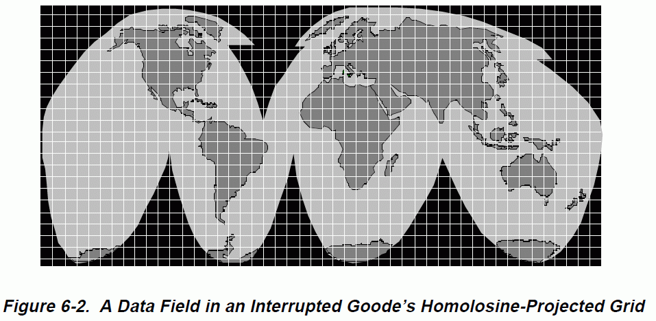
HDF-EOS grids are described by a pair of corner locations (upper left and lower right) and a set of projection equations (or references to them) which can be used to compute the latitude and longitude for any grid point. Depending on the projection, the projection may be "interrupted", i.e., certain grid points are masked and do not have a corresponding latitude and longitude (see the grid points which fall into the black region in the figure below).
Here's an example:
    GridName="SET2"
    XDim=2400
    YDim=2400
    UpperLeftPointMtrs=(-180000000.000000,-90000000.000000)
    LowerRightMtrs=(180000000.000000,90000000.000000)
    Projection=GCTP_SNSOID
    ProjParams=(6311007.1810000,0,0,0,0,0,0,0,0,0,0,0,0)
Tags, Data Fields in EOS speak, are two- to eight-dimensional arrays referencing the grid. Example (pressure at sea-level):
OBJECT=DataField_2
    DataFieldName="Psea_level"
    DataType=H5T_NATIVE_FLOAT
    DimList=("YDim","XDim")
    MaxdimList=("YDim","XDim")
END_OBJECT=DataField_2
HDF-EOS Swaths
For an introduction see section 5 of [HDF-EOS1].
OED says:
swath, swathe
...
4. transf. and fig. a. A broad track, belt, strip, or longitudinal
extent of something.
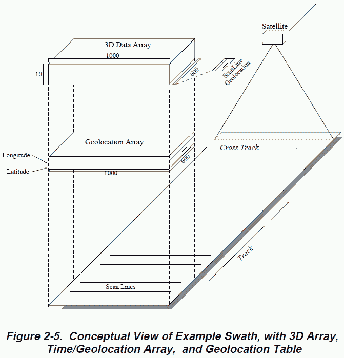
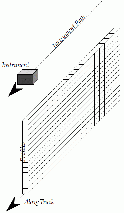
Satellite-based instruments take series of scans perpendicular (cross track) to the ground track of the satellite. Sensors may measure vertical profiles instead of taking cross track scan lines.
 | 
|
Dimension maps define the relationship between geolocation field dimensions and data field dimensions. In the simplest case, they are just offset/increment-type mappings.
The most common tags on swaths are the following.
Geolocation Fields
Geolocation fields tie the swatch to locations on the Earth's surface. Fields must be one- or two-dimensional (profile- or scan-oriented).
| Field Name | Data Type | Format |
| Longitude | float 32 or float64 | decimal degree, range [-180.0,180.0] |
| Latitude | float 32 or float64 | decimal degree, range [-90.0,90.0] |
| Colatitude | float 32 or float64 | decimal degree, range [0,180.0] |
| Time | float64 | TAI93 [seconds until (-)/since (+) midnight 1/1/93] |
Data Fields
Data fields may have up to eight dimensions. The first dimension (time or track count) must be "unlimited" (HDF5) and precede the other dimensions representing scan- or profile-dimensions.
Profile Fields
Profile fields are vertical, i.e., not cross track.
Example
See page 13-19 of "HDF-EOS Aura File Format Guidelines" for an example
HDF-EOS Points
For an introduction see section 4 of [HDF-EOS1].
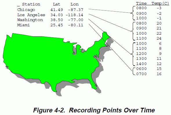
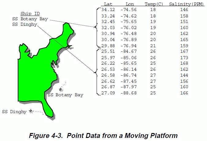
A Point Data set is made up of a series of data records taken at (possibly) irregular time intervals and at scattered geographic locations. Point Data is the most loosely organized form of geolocated data supported by HDF-EOS. Simply put, each data record consists of a set of one or more data values representing, in some sense, the state of a point in time and/or space. [HDF-EOS1]
The two figures below are from section 4 of [HDF-EOS1].
 | 
|
Data sets are combined into chains of levels which are linked (bi-directionally). Starting with 0, up to eight levels are supported (in HDF-EOS).
HDF-EOS Zonal Averages
"Swaths without geolocation"
References
* [HDF-EOS1] HDF-EOS Library s Guide for the ECS Project, Volume 1: Overview and Examples
* [HDF-EOS2] HDF-EOS Library Users Guide for the ECS Project Volume 2: Function Reference Guide

|
EECS Home |
McCormick Home |
Northwestern Home |
Calendar: Plan-It Purple © 2011 Robert R. McCormick School of Engineering and Applied Science, Northwestern University "Tech": 2145 Sheridan Rd, Tech L359, Evanston IL 60208-3118 | Phone: (847) 491-5410 | Fax: (847) 491-4455 "Ford": 2133 Sheridan Rd, Ford Building, Rm 3-320, Evanston, IL 60208 | Fax: (847) 491-5258 Email Director Last Updated: $LastChangedDate: 2014-09-17 14:51:09 -0500 (Wed, 17 Sep 2014) $ |


